Old Man Winter Points Crosshairs On US Mid-Atlantic
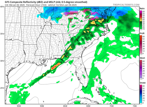
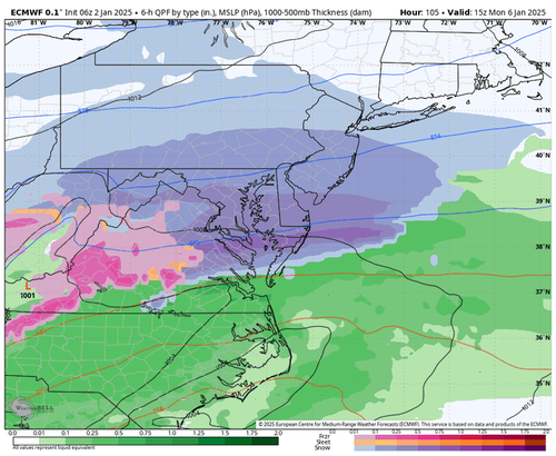
The latest forecast model guidance shows a possible winter storm or wintery mix late Sunday night into Monday for the Mid-Atlantic region.
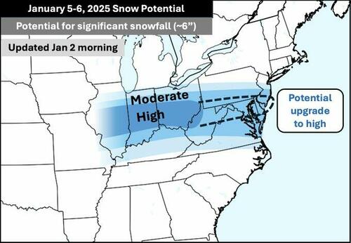
“Quick morning update to my snow potential map for the Jan 5-6 storm – this is still subject to some changes, but confidence is gradually increasing on the following corridor,” meteorologist Tomer Burg wrote on X.
Mike’s Weather Page wrote in a separate X post, “Things stay stable through the weekend for the SE. A Monday AM cold front line incoming here. Cold air behind for next week with the next round towards the following weekend. That’s the south and/or east snow maker question mark.”
“The Northeast Direct Snow Train will be making stops in DC, Baltimore, Philly and NY City on Monday,” WBAL TV (Baltimore-based) meteorologist Tony Pann wrote on X.
More on the incoming storm from meteorologist Ryan Maue.
Powerful winter storm ❄️with Gulf of Mexico moisture will surge up/over colder air to the north causing heavy freezing rain, sleet, and then snow on a West to East track from Kansas through St. Louis, along Ohio River, into Washington D.C.
1″ to 2″ of precipitation (if liquid)… pic.twitter.com/RtwMmld2LI
— Ryan Maue (@RyanMaue) January 2, 2025
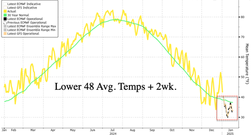
Bloomberg data shows that the average temperatures in the Lower 48 are set to trend under a 30-year mean for the next two weeks. What happened to global warming?
By the way…
“Doesn’t Fit MSM Narrative”: Latest Arctic Ice Data Shows 26% Larger Than 2012 https://t.co/FdA02ZxvkT
— zerohedge (@zerohedge) December 26, 2024
Latest reporting on weather and energy markets:
- Dec. 27: “All Systems Go” For Polar Vortex Air Dumping Into US
- Dec. 30: NatGas Futures Spike Ahead Of Forecasted “Historic Cold”
Old Man Winter is inbound.
Tyler Durden
Thu, 01/02/2025 – 13:00


