Ports Preparing For Hurricane Helene As Storm Bears Down On Florida
By Brinley Hineman of FreightWaves
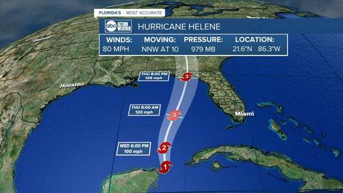
Florida ports are preparing for Hurricane Helene, which is expected to make landfall in the state on Thursday and bring life-threatening conditions with it.
The National Hurricane Center on Wednesday upgraded Helene from a tropical storm to a hurricane. A large portion of Florida and the Southeast are expected to see flooding, strong winds and rainfall of 5 to 10 inches.
SeaPort Manatee in Florida, which moves more than 11 million tons of cargo annually, closed Wednesday for ship traffic. Port Panama City, which handled 2 million tons of cargo last year, suspended container gate operations at noon local time on Wednesday and planned to suspend general cargo operations at 4 p.m. The Port of Key West, a major economic driver for the city, closed Wednesday.
Tampa International Airport announced Wednesday it was suspending operations Thursday ahead of the hurricane.
The U.S. Coast Guard reported the following ports were open with restrictions Wednesday: Canaveral, Fernandina, Jacksonville, Fort Myers, Sarasota, St. Petersburg and Tampa in Florida; Brunswick and Savannah in Georgia; and Mobile in Alabama.
The National Weather Service predicts Helene will turn north Wednesday before making landfall Thursday night on the coast of Florida’s Big Bend. It is unclear how strong Helene will grow, but forecasters said the storm is expected to “be a large, major hurricane.”
Florida will begin experiencing tropical storm conditions Wednesday before the storm reaches Georgia and South Carolina on Thursday, the hurricane center said.
The Southeast through Appalachia will see 5 to 10 inches of rainfall, with some areas seeing around 15 inches, meteorologists predict. Considerable flash flooding is expected, and landslides are possible in southern Appalachia.
Tornadoes are possible Wednesday in Florida and southern Alabama. The tornado risk will increase Thursday across Florida, Georgia and South Carolina.
AccuWeather said Helene could strengthen into a Category 4 hurricane.
Tyler Durden
Wed, 09/25/2024 – 23:00

