Tropic Trouble Brewing In Gulf Of Mexico Could “Slingshot” Towards Offshore Oil Rigs
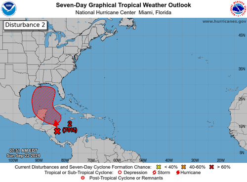
The latest Tropical Outlook from the National Hurricane Center indicates a 70% probability of tropical cyclone formation in the Gulf of Mexico or the Caribbean Sea over the next seven days. Forecast models predict that a tropical storm could develop early next week, potentially making landfall along the Gulf Coast—the location of America’s top offshore oil/gas rigs and refineries on the mainland—by late next week.
“Northwestern Caribbean Sea and Gulf of Mexico: Disorganized showers and thunderstorms located over the western Caribbean Sea and portions of Central America are associated with a very broad area of low pressure. Environmental conditions appear favorable for gradual development of this system during the next several days. A tropical depression is likely to form while the system moves slowly northward across the northwestern Caribbean Sea and Gulf of Mexico through the end of the week,” NHC wrote in an update on Sunday morning.
Since Thursday, we have been monitoring potential tropical development via various weather models because this potential storm threatens US oil/gas infrastructure.
“Something Brewing In Gulf Of Mexico” As Confidence Grows In Cyclone Formation Next Week
The Weather Channel’s Jim Cantore wrote on X, “One of the things to consider with this week’s pending tropical threat is where the “slingshot” sets up. The slingshot is the upper low (blue) that could ventilate the system first and aid in intensification, then slingshot it into the coast. The stronger it is at landfall the deeper inland the more intense parts of it get. Guidance has much to sort out with all the players coming together. We should have an invest soon as NHC has issued a 10% area in 48hrs and marked a starting point.”
One of the things to consider with this week’s pending tropical threat is where the “slingshot” sets up. The slingshot is the upper low (blue) that could ventilate the system first and aid in intensification, then slingshot it into the coast. The stronger it is at landfall the… pic.twitter.com/QCdYVtRAuX
— Jim Cantore (@JimCantore) September 22, 2024
Washington Post’s Matthew Cappucci wrote on X that a hurricane will likely form in the Gulf of Mexico…
A hurricane is likely in the Gulf of Mexico. Stay tuned in in Florida, Alabama, Mississippi or Louisiana!
I’ll have an update in the @MyRadarWX app in the morning. Be sure to follow me on TikTok as well (trying to get better at verticals for the youth). pic.twitter.com/8zlIhVzTK8
— Matthew Cappucci (@MatthewCappucci) September 22, 2024
“Mike’s Weather PageOvernight GFS/EURO ensembles on http://weathernerds.org. Huge consistency. EURO catching up to the GFS. Timing here Friday. Many already make landfall by then. Getting real Florida IMO,” Mike’s Weather Page wrote on X.
Overnight GFS/EURO ensembles on https://t.co/j6cXc9FWby. Huge consistency. EURO catching up to the GFS. Timing here Friday. Many already make landfall by then. Getting real Florida IMO. https://t.co/Hk3pbO84Yf pic.twitter.com/j652aq388q
— Mike’s Weather Page (@tropicalupdate) September 22, 2024
Landfall in Florida, Georgia, Alabama, Mississippi and or Louisiana?
While uncertainty remains, there is a focusing of tropical tracks in the eastern Gulf late in the week.
Ensemble “orb” guidance is leaning toward a faster emergence into the Gulf, with states like Florida, Georgia, Alabama, Mississippi & Louisiana on watch…
Old run ➡️ new run pic.twitter.com/vRiQnbGXKn
— Ben Noll (@BenNollWeather) September 22, 2024
About 15% of the nation’s total crude production capacity via offshore rigs is in the cone uncertainty. Also, about 45% of the US refining capacity resides at major refineries in Texas, Louisiana, Mississippi, and Alabama. Via Bloomberg data…
There’s a high probability the forecast could can change in the next five days.
Tyler Durden
Sun, 09/22/2024 – 16:55

