How Iran Used An Advanced Turkish Drone To Find Raisi’s Helicopter
A Turkish high-altitude, long-endurance drone played a central role in finding the wreckage of the helicopter that was carrying Iranian President Ebrahim Raisi and his delegation on Sunday night.
Iranian search and rescue officials reported late on Sunday evening that they believed the helicopter had made a “hard landing” in Iran’s East Azerbaijan province. However, progress was hindered for several hours due to adverse weather conditions, including dense fog and rain. Turkish Transportation Minister Abdulkadir Uraloglu highlighted another complicating factor: the helicopter either did not have its transponder on or lacked one entirely.
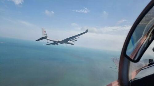
An Akinci drone seen from an Azerbijani Mikoyan MiG-29, AFP/handout
“We track every aerial signal since Iran is part of the area we are responsible for in search-and-rescue operations,” Uraloglu told Turkish media on Monday. “But we couldn’t get any signal at all. It must have been received, but it didn’t happen.” As the search ramped up and proved so tricky, Tehran asked Ankara for assistance.
“Tehran requested a night vision search-and-rescue helicopter and technical help,” a Turkish diplomatic source told Middle East Eye. Subsequently, the Turkish defense ministry announced it had allocated an Akinci high-altitude, long-endurance drone to aid in the search.
Turkish security sources said the defense ministry proposed deploying the Akinci to the area even without an official request from Iranian authorities, who quickly accepted the offer. The sources said the Akinci took off from the armed drone air base in eastern Turkey’s Batman at 11.18 pm.
The Akinci, a model produced by the Turkish drone manufacturer Baykar since 2019, can fly at altitudes of up to 40,000 feet and remain airborne for more than 24 hours, covering vast areas.
“Akinci has capabilities to operate in hard terrain and foggy weather thanks to its high-altitude flight capabilities and thermal technology,” a defense industry source told MEE. “It is a very good match in this sense.”
The drone, which is capable of reaching speeds of up to 400 kmph and efficiently scanning terrain at lower speeds, crossed the Iranian border from the Turkish city of Van, arriving in Iran at 12:45 am on Monday. The defense ministry sources said the drone was able to operate when all other aircraft were grounded because of the bad weather.
As the Akinci commenced its surveillance mission, Turkish public news agency Anadolu launched a live stream on X, formerly known as Twitter, showcasing footage from the drone. The stream attracted 3.1 million viewers at its peak.
At 2:22 am, the Akinci reported its first heat source, instantly sharing the image with Iranian officials. Rescue workers were only able to reach the wreckage at 5.46 am.
Türkiye’s Akinci drone was the most-watched aircraft in the world as it circled Iranian skies, searching for the downed helicopter that was carrying Iranian President Raisi pic.twitter.com/nllPwqEdYK
— TRT World (@trtworld) May 20, 2024
A source familiar with the Akinci operation told MEE that the crash site was close to the area the drone had repeatedly surveyed throughout the night. The coordinates suggested by the Akinci were in close proximity to the crash site, the source added.
As weather conditions improved, the Akinci returned to Turkey, arriving around 6 am. The drone drew a crescent and star over Van Lake on flight radar, symbolizing Turkish capabilities. On Monday, some noted on X that the Akinci’s initial route into Iran through Tabriz appeared to include a flight path over sensitive Iranian military sites, such as the Amand rocket site, Khoi Airport, Tabriz Airport, and the Iranian army’s rapid response base.
Tyler Durden
Mon, 05/20/2024 – 13:40

