Hurricane-Stoking La Nina To Persist Through Peak Season
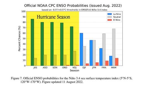
As peak hurricane season is underway, the odds of La Nina sticking around for at least a few months are rising, potentially leading to more hurricanes and tropical storms.
According to the US Climate Prediction Center’s latest data, there’s an 80% chance of cool waters across the equatorial Pacific Ocean through October. Last month the agency estimated 62% odds of La Nina for the same period, a noticeable increase over the previous month.
The weather phenomenon known as La Nina helps to fuel tropical development by cutting down on the amount of wind shear across the western Atlantic. High wind shear can disorganize the structure of tropical systems by weakening them or destroying them.
We pointed out earlier this month that the first two months of hurricane season have been relatively quiet, but that is all expected to change as peak hurricane season has arrived.
Increased tropical storm activity usually begins in August and lasts through early October.
The concern with entering the most active part of hurricane season, plus a possible boost in the severity of storms due to lingering La Nina, is that more areas of the US are prone to possible landfall.
The National Hurrican Center has identified one disturbance in the Atlantic, though formation odds in the next 48% hours are extremely low.
And here’s what La Nina means for the weather conditions across the country this fall.
Another problem is if a hurricane or tropical storm were to make landfall on US soil and damage infrastructure, a critical supply shortage of transformers, distribution lines, and poles could prolong power outages. Then there’s the risk of a tropical system slamming into the Gulf Coast of the US, where major oil/gas refinery operations exist — any disruption due to storm-related damage could reverse the steepest declines in fuel prices since GFC.
Tyler Durden
Thu, 08/11/2022 – 22:40

