As East Coast Says Goodbye, Debby, A New Tropical Threat Emerges
For those on the East Coast, finally – goodbye, Debby. But now, the focus shifts to a new tropical system forming in the Atlantic Basin.
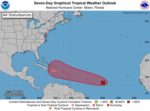
The National Hurricane Center’s latest advisory note on ‘AL98’ said shower and thunderstorm activity has increased in association with a tropical wave between the Cabo Verde Islands and the Lesser Antilles. Tropical development probabilities currently stand at 30% over the next 48 hours and 80% over the next seven days.
Here’s the full advisory note:
Near the Lesser and Greater Antilles (AL98): Shower and thunderstorm activity has increased since yesterday in association with a tropical wave located roughly midway between the Cabo Verde Islands and the Lesser Antilles. Gradual development of this system is possible during the next couple of days while it moves westward to west-northwestward across the central tropical Atlantic. Afterwards, conditions are expected to become more conducive for development, and a tropical depression is likely to form by the early to middle part of next week while the system approaches and then moves near or over the Lesser Antilles. The system is forecast to continue moving generally west-northwestward and could approach portions of the Greater Antilles by the middle to latter part of next week.
Formation chance through 48 hours…low…30 percent
Formation chance through 7 days…high…80 percent.
AL98’s seven-day trajectory model
Jim Cantore of the Weather Channel wrote on X, “Invest #98L is gradually get its act together, and as these things go we could easily have a depression or storm close to the Leeward Islands Tuesdayish.”
Invest #98L is gradually get its act together, and as these things go we could easily have a depression or storm close to the Leeward Islands Tuesdayish. From there, a trip north of the islands or a trip into the Greater Antilles is possible with a ramp up in intensity too for… pic.twitter.com/Yc5KnyqccX
— Jim Cantore (@JimCantore) August 10, 2024
“A hurricane is likely to be near the US East Coast next weekend, but how close?” Ben Noll, a meteorologist with New Zealand’s National Institute of Water & Atmospheric Research, wrote on X.
A hurricane is likely to be near the U.S. East Coast next weekend, but how close?
Most ECMWF-EPS members are safely offshore, nudged by an upper trough, but a small handful are close enough for a U.S. impact.
Atlantic Canada & Bermuda will want to watch this one closely! pic.twitter.com/g7B9mHecZ9
— Ben Noll (@BenNollWeather) August 10, 2024
If AL98 does become a named storm, it will be called “Ernesto.” Spaghetti models show AL98’s potential track could make a presence on or near the East Coast.
The hurricane season is beginning to ramp up, as the peak is in mid-September.
Tyler Durden
Sat, 08/10/2024 – 16:55

