Models Show Growing Threats In Tropics Could Impact West Coast Of Florida
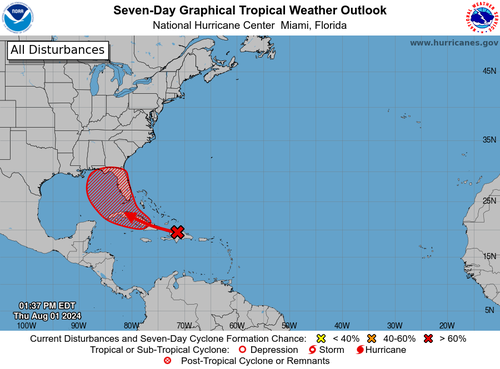
Forecasters at the National Hurricane Center (NHC) are tracking a tropical wave that could soon form over the eastern Gulf of Mexico or near the Florida peninsula by late weekend or early next week. New spaghetti models show the storm’s potential landfall impacts are across the west coast of Florida.
A Thursday morning advisory note from NHC forecasters indicated that Invest 97L has a 30% chance of developing into a tropical system within the next 48 hours. Over the next seven days, those odds increase to about 70%.
Matthew Cappucci, a meteorologist for Capital Weather Gang, posted a short video on X explaining how the next tropical system is likely to form in the Gulf of Mexico. He said multiple weather models agree that “Debby is likely to form in the Gulf of Mexico and likely to bring direct impacts.”
🌀 A tropical wave currently located near Hispaniola has an increasing chance of becoming a named storm, and potentially entering the Gulf of Mexico.
The risk of land impacts is increasing.
MyRadar meteorologist @MatthewCappucci has a tropical weather update. pic.twitter.com/lwxFX42TKG
— MyRadar Weather (@MyRadarWX) August 1, 2024
Here’s one of the first spaghetti models for Invest 97L released earlier today that shows potential landfall impacts on the west coast of Florida.
“Even though its still disorganized, the thunderstorms are much more numerous and intense today,” meteorologist Jim Cantore wrote on X.
Perhaps its a good thing #invest97l is spending some of its time over Hispaniola and Cuba in the near term. Even though its still disorganized, the thunderstorms are much more numerous and intense today. NHC at 30/70% at 2pm pic.twitter.com/pE6IZ7rVTI
— Jim Cantore (@JimCantore) August 1, 2024
Keep an eye on Invest 97L’s developments into the weekend.
Tyler Durden
Thu, 08/01/2024 – 19:45

