Hurricane Ian Strengthens To Powerful Category 4 As Florida Landfall Imminent
Update (0739ET):
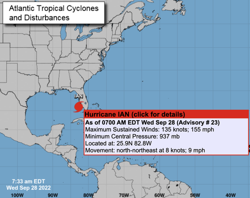
Hurricane Ian continues to strengthen ahead of landfall. As of 0733 ET, the National Hurricane Center said Ian’s sustained maximum winds were 155 mph, just 2 mph shy of a Cat. 5 storm.
* * *
Hurricane Ian strengthened into a powerful Category 4 storm expected to make landfall on Florida’s southwest coast today and then traverse central Florida and emerge in the Atlantic by Thursday.
At 0500 ET, the National Hurricane Center said Ian sustained maximum winds of 140 mph and gusts up to 165 mph. The storm’s center was about 75 miles west-southwest of Naples and 105 miles south-southwest of Punta Gorda, moving north-northeast at 10 mph.
“Ian is forecast to approach the west coast of Florida as an extremely dangerous major hurricane, weakening is expected after landfall.
“On the forecast track, the center of Ian is expected to approach the west coast of Florida within the hurricane warning area this morning, and move onshore later today. The center of Ian is forecast to move over central Florida tonight and Thursday morning and emerge over the western Atlantic by late Thursday,” NHC senior hurricane specialist Daniel Brown told Orlando Sentinel.
Ian’s path has shifted south of Tampa Bay, and landfall is now expected between Fort Myers and Sarasota on Wednesday morning or early afternoon before moving across the central part of the state.
NHC warned a “life-threatening storm surge is expected along the Florida west coast and the Lower Florida Keys,” with “devastating wind damage” expected near Ian’s center.
“Catastrophic flooding is expected across portions of central Florida with considerable flooding in southern Florida, northern Florida, southeastern Georgia and coastal South Carolina,” the weather agency continued.
“It’s going to be historic,” National Weather Service Melbourne meteorologist Kole Fehling in Melbourne, referring to the storm’s landfall impacts.
Fehling said Central Florida could be swamped with 15 to 20 inches of rainfall, with some areas receiving upwards of 24 inches.
“The normal value for the amount of rainfall over the entire year is about 52 inches,” he said. “So if we were to see those higher- end totals, we could be experiencing half of our total annual rainfall in a very short period of time.”
On Tuesday night, Florida Governor Ron DeSantis told residents:
“You need to evacuate now. You’re going to start feeling major impacts of this storm relatively soon.”
Millions of Floridians are under evacuation orders or advisories as DeSantis activated the National Guard earlier this week before the storm’s arrival.
There are notable economic impacts due to adverse weather conditions in the region. On Tuesday evening, US energy companies idled 190,000 barrels of daily crude production, some 11% of US Gulf of Mexico output.
Bloomberg pointed out that the “nation’s production of phosphate fertilizer” is in the storm’s path.
Chuck Watson, a disaster modeler with Enki Research, said Mosaic’s New Wales plant is “right in the middle of the damage swath,” adding the facility “could be out for weeks.”
Bloomberg said Ian could cause $45 billion in damage, which would make it one of the most costly storms in the country’s history.
By late Tuesday, over 2,000 flights to and from Florida were canceled. Flight delays and cancelations could spill over to the rest of the country.
Tyler Durden
Wed, 09/28/2022 – 07:12

